Trail Walking Le Pradet - Les forts de la Colle Noire, 16-05-2025 - Photo

Les forts de la Colle Noire, 16-05-2025

© OpenStreetMap contributors
Length
Length
14.3 km
Max alt
Max alt
285 m
Uphill gradient
Uphill gradient
427 m
Km-Effort
Km-Effort  
20 km
Min alt
Min alt
1 m
Downhill gradient
Downhill gradient
426 m
Boucle
Boucle
Yes
Creation date :
2025-05-16 06:38:35.969
Updated on :
2025-05-31 16:18:13.603

(0 Reviews)

Walking
Walking
3h59
Difficulty : Medium

Scan this QR Code to open this trail in the SityTrail application

FREE GPS app for hiking

Logo SityTrail SityTrail

IGN / Geographical institutes

Download SityTrail from the App Store Download SityTrail from Google Play

Logo SityTrail SityTrail Plus

The world is yours!

Download SityTrail from the App Store Download SityTrail from Google Play Download SityTrail on Huawei AppGallery

About

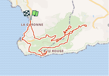
Trail Walking of 14.3 km to be discovered at Provence-Alpes-Côte d'Azur, Var, Le Pradet. This trail is proposed by Christiancordin.

Description

Pk plage de la Garonne, les Oursinières, le pas des Gardéens, sentier de découverte, musée de la mine, fort de la Bayarde, fort de la Colle Noire (ATTENTION le tour du fort est à éviter si les personnes sont sujettes à vertige) fort de la Gavaresse, Mauvallon, la Garonne.

Elevation profile

Photos

Positioning

Country:
France
Region :
Provence-Alpes-Côte d'Azur
Department/Province :
Var
Municipality :
Le Pradet
Location:
Unknown
Start:(Dec)
Start:(UTM)
257904 ; 4775429 (32T) N.


Close
My subscriptions